In 1969 I was the NW Ont geophysical foreman for a major Canadian mining firm. Selco had announced development of their South Bay Zn, Cu, Ag mine, kicking off a staking rush. My company responded by flying a fixed-wing airborne survey from South Bay northward along that portion of the Con Trend. At the same time they had picked up a 200 claim option near North Spirit Lake, so with up to 20 men of various disciplines roaming around, I had a busy yet enjoyable summer.
In early Sept with season’s end near and manpower drifting away, I myself took two young lads in to check the last of our anomalies – an orphan on the north western fringe of the airborne survey. We flew in by Beaver and threw up a quick fly camp. We had no radio and had told the air service to give us three good-weather work days with a return flight in the pm of day four. This schedule would give us time to do a competent preliminary ground survey while enabling us to skedaddle before Sept weather locked us in.
The 20-claim block had been staked, cut and chained by Jean Alix of Val D’Or, the go-to people of the day. The line spacing was 400’ with 100’ stations, giving us 20 line-miles to survey.
We used a Crone JEM (Junior Electro-Magnetic) and a McPhar MF-1 fluxgate magnetometer. The JEM was a battery powered, dual-frequency transceiver unit. Used in-line (shoot back), with a coil separation of 200’, it gave us 100’ of depth penetration, considered adequate for a primary survey. As an added feature (unknown and unused by less experienced operators) the JEM could easily be reconfigured to vertical-loop mode – an excellent tool for field interpretation. The McPhar fluxgate was one of the preferred magnetometers of that era.
We had done the usual air recon before setting up camp so I knew we would have no difficult topography to deal with. It was my usual habit to start all field surveys at the furthest point from camp. Thus, if we had a couple of miles to do before our return flight came in, we could complete the survey in early am.
We did the survey in loops with myself as lead hand always on the south. The mag man, a new hire that spring, was proving to be a “keeper” but I still kept him close at hand to monitor his readings in case some detail was indicated.
Day one proved to be uneventful – our readings were as flat as the ground we walked on. The area was treed with mature poplar and jackpine with scant underbrush. We saw no outcrop nor float.
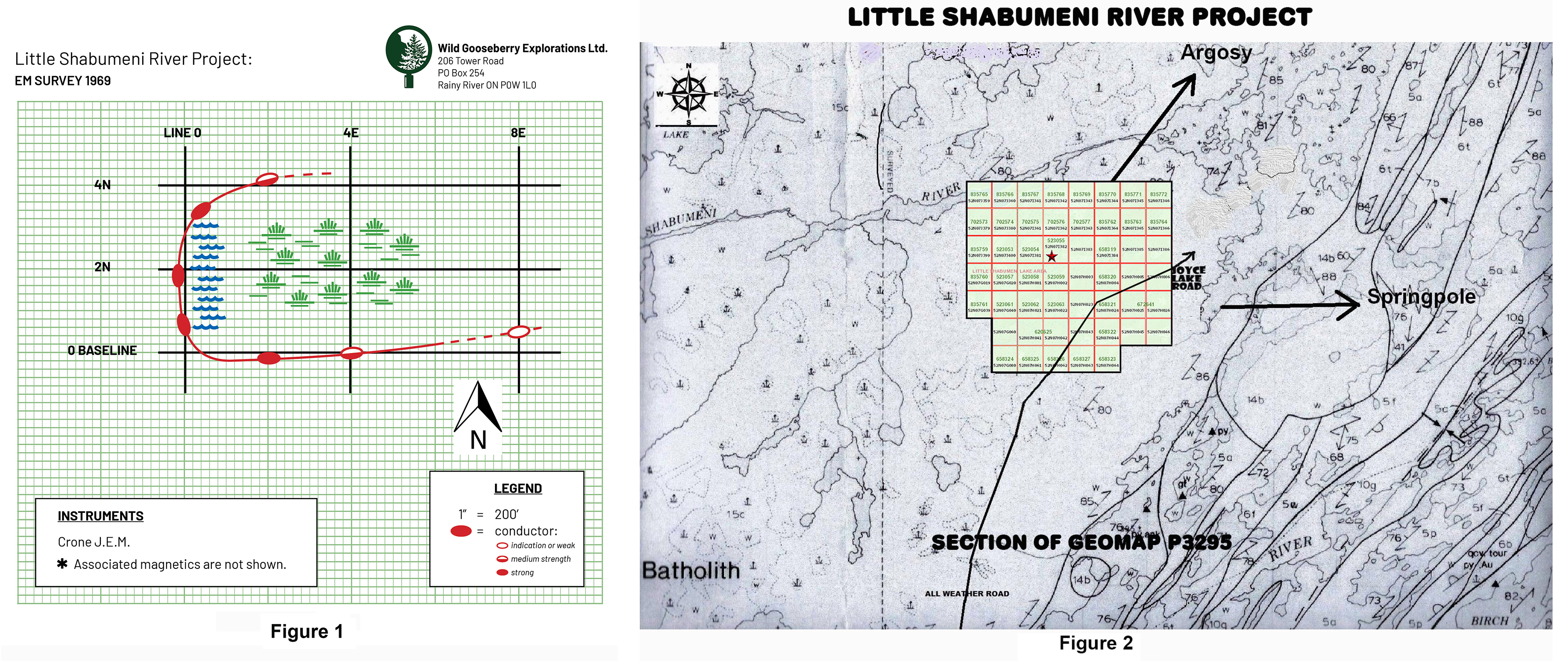
Day two started out likewise – flat, flat. Near noon, coming up what I call line 8E, (see sketch) I picked up an indication. It was only 3 dip-angle degrees but I was always aware of my surroundings. Topo can give you hints and we were at the tip of what appeared to be an open area to our west.
Coming down line 4E we found the open area to be a dry swamp – hardly a depression but within its boundary there were NO trees – only sparse clumps of willows. At the swamp’s southern perimeter we picked up a medium strength conductor with associated mag activity. (Figure three)
Coming up line Zero we hit the swamp at its west end and we were now virtually in the center of our 1969 claim block. Here the conductor was quite strong with a low-to-high frequency ratio of 60%. We also had a medium strength flanking mag high indicating a southerly dip.
We continued northward along the western fringe of the swamp which had ended with a berm of perhaps two feet. To our right were small pools of water and to our left was a fringe of cedars – the only cedar trees we had come across. My EM readings became out-of-phase (noisy) and I had difficulty pinning down a null point. Magnetics were also erratic but after 300 – 400’ the swamp boundary curved eastward and our readings told us that we were leaving the conductive zone.
We reviewed our field notes and it was obvious that we had been following rather than intersecting the conductor. We returned to the south side of the swamp and I switched the JEM to vertical loop mode. With my partner transmitting, I read a series of short E/W lines all at 50’ coil spacing. As I had suspected, the conductor followed the curve of the swamp, folding back eastward. I also proved that the conductor was at a depth of less than 25’ at the fold. The magnetic picture also cleared up, but without proper grid control it was pointless to record the readings.
However, before we moved on, we ran two short compass and pace shoot-back lines – one at 2E and one at 2W. 2E confirmed the fold and 2W confirmed that the zone did NOT extend westward. I would have liked to cut and chain a small detail grid but we lacked the tools and the time. We still had ten line-miles to do and a date with warm beds and hot running water in Red Lake. The rest of the grid replicated the east half – no action.
In Red Lake I tuned up my field maps and wrote a report recommending a small detail grid and a priority one drill target. My superiors demurred with the decision coming from Toronto. “Too expensive!” and even now, many years later, I do not understand why. However – in those days we had a reputation of doing excellent field work with piss-poor drill follow-up.
A reader of this may think the foregoing has been unnecessarily descriptive, however there is a point to this process: In 1969 I was in year ten, geophysically speaking. I had covered the Shield from Contwoyto Lake NWT to Chibougamau PQ, including almost every greenstone belt in Ontario. I had been part of detailed surveys of two future producers but: